FAST CREATE INTELLIGENT TECHNOLOGY
We Don't Just Build DronesWe Build the Entire Airborne Operation
The XELER flight platform, R-series AI gimbals, SkyOnLive live video and T-TAK joint command — all engineered by one team in Taiwan, from R&D to deployment.
CAPABILITIES
Three Core Capabilities
Flight Platform
XELER industrial quadcopter, designed and built in Taiwan — cybersecurity certified, centimeter RTK, MESH networking.
Discover XELERAI Payloads
R1 full-frame mapping camera, R2L AI zoom gimbal and R3 EO/IR dual-sensor gimbal — onboard Nvidia Xavier NX inference with user-trainable models.
Discover payloadsMission Software
SkyOnLive live-video platform and the T-TAK joint command system, built in-house: streaming, replay, evidence and multi-drone dispatch in one stack.
Discover T-TAK
01 · FLIGHT PLATFORM
XELER Industrial Drone
A long-endurance, long-range platform with centimeter positioning. Three quick-release gimbals share one P-Mount interface — one aircraft for mapping, inspection, SAR and surveillance.

- 70 min
- Max flight time (no payload)
- 8 km
- Control range
- 1 cm
- RTK horizontal accuracy (+1ppm)
- 5000 m
- Max service ceiling
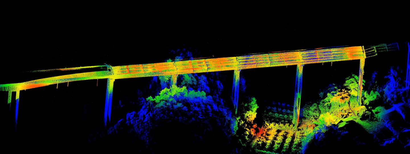
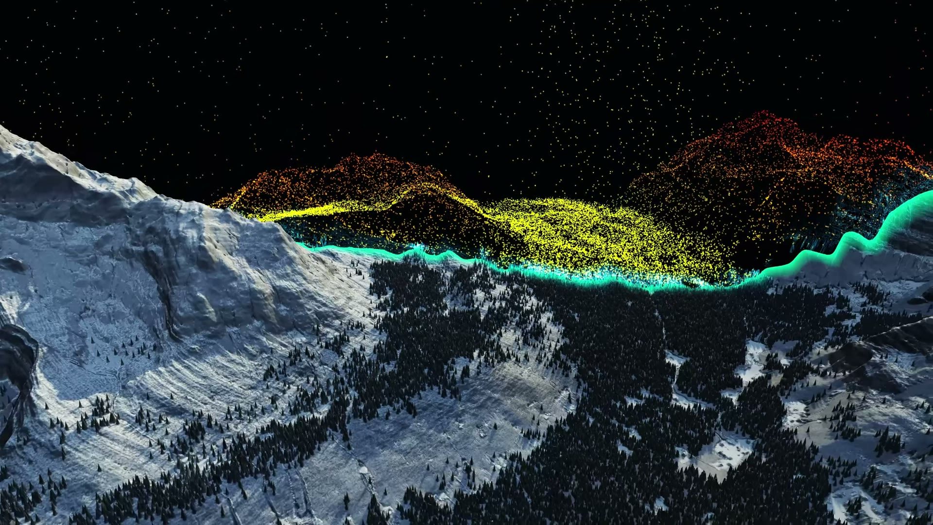
LIDAR POINT CLOUD
Centimeter 3D Point Clouds, Straight From Flight
With the R1 mapping camera and LiDAR, a single XELER sortie produces centimeter-grade point clouds and reality models — this is actual field output.
02 · AI PAYLOADS
R-Series AI Gimbals
Three quick-release gimbals, one open interface: MAVLINK 2.0, onboard Nvidia edge computing, compatible with PX4, ArduPilot and Cube autopilots.

R1Full-Frame Mapping Camera
- Sony full-frame 61.0 MP
- Interchangeable 24 / 40 / 50 mm lenses
- ±3 cm accuracy @ 100 m

R2LAI Zoom Gimbal
- 4K sensor with 720x hybrid zoom
- Laser rangefinder 5–1200 m
- Nvidia Xavier NX, 21 TOPS

R3EO / IR Dual-Sensor Gimbal
- Visible + thermal imaging
- 360° limitless pan
- Lightweight at 815 g
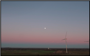
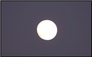
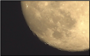
From the Horizon to Lunar Craters
R2L's 720x hybrid zoom, unedited: one camera position, from a wind-farm panorama all the way to the surface of the moon.
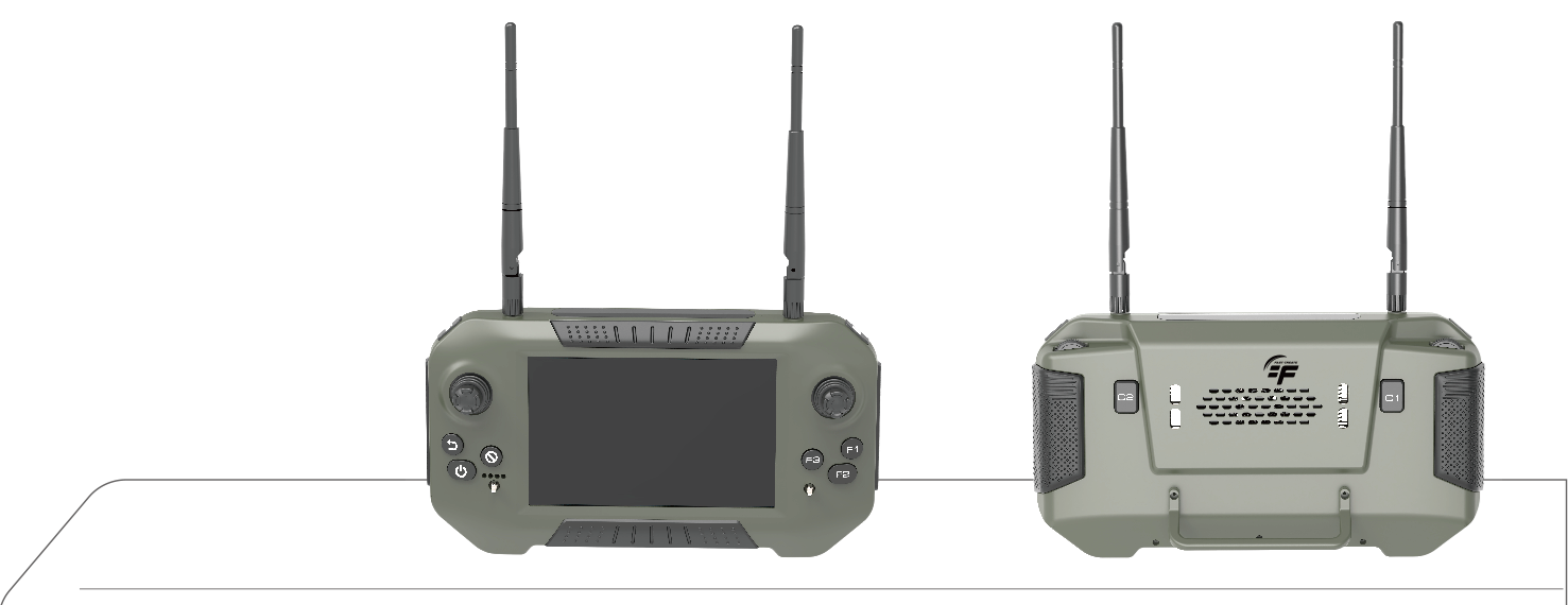
GROUND CONTROL STATION
YUTA Handheld Ground Station
A 7-inch all-in-one ground station combining video, telemetry and RC. 10 km range, 4.5-hour endurance, open Android 11 — paired with XELER out of the box.
- MediaTek 8-core, sunlight-readable display
- PIX / APM and QGroundControl support
- Made in Taiwan
EDGE AI
AI On Board, Not in the Cloud
Every R-series gimbal carries an Nvidia Jetson Xavier NX — the world's smallest embedded AI supercomputer. Detection, tracking and recognition happen in the air, with no dependence on ground compute or connectivity.
- 21
- TOPS AI performance (INT8)
- 384
- CUDA cores
- 48
- Tensor cores
- .pt
- Upload your own models
- Real-time detection with the YOLOR unified network
- Edge + cloud dual-AI workflow
- Custom models for bridge cracks, SAR human detection and more

03 · JOINT COMMAND
T-TAK Joint Command — the Whole Scene on One Screen
Our multi-drone operations system: draw search areas, dispatch drones and ground teams in real time, and track coverage, sightings and gimbal video as it happens.
- Real-time fleet command and telemetry
- Search-area planning, dispatch and coverage tracking
- Drone, pilot and ground-team coordination
- Direct EO/IR gimbal control with AI tracking

LIVE VIDEO PLATFORM
SkyOnLive — Live Video in 2 Seconds
Drone video reaches command centers and authorized viewers instantly. One-click LINE authorization, on-demand replay, and fingerprint-verified clips.
- < 2 s
- End-to-end latency
- 360 days
- Video retention
- SHA-256
- Clip fingerprints
- AES-256
- Encryption at rest
MISSION PROFILES
One System, Every Kind of Scene
Search & Rescue
Thermal night vision, AI human detection, air-ground dispatch.
Mapping
Centimeter aerial survey, 3D point clouds and reality modeling.
Surveillance & Inspection
720x zoom for long-range observation and infrastructure inspection.
Aerial Cinematography
Full-frame image quality with 3-axis stabilization, day or night.
AGRICULTURE
Where We Started: Agriculture
Fast Create began with the Super S5 crop-protection drone — first in Taiwan to earn official performance certification, machinery subsidies and cybersecurity approval.
Agriculture solutionsECOSYSTEM
- NVIDIA
- SONY
- PX4
- ArduPilot
- Cube Pilot
- QGroundControl
- MAVLINK 2.0